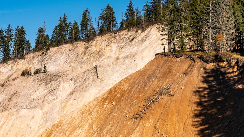
- A massive rock avalanche triggered a 481-meter tsunami in southeastern Alaska’s Tracy Arm fjord in August 2025.
- The event was equivalent to a 5.4 magnitude earthquake and was caused by the sudden release of 64 million cubic meters of rock.
- The tsunami was a landslide-generated tsunami, differing from tectonic tsunamis caused by undersea earthquakes.
- Confinned, steep fjords like Tracy Arm can produce extraordinary wave heights due to the unique geography.
- The event raises concerns about the potential impact of climate change on such geological events in the future.
In August 2025, a seemingly remote and uninhabited corner of southeastern Alaska became the epicenter of one of the most extreme geological events in modern history. When a mountainside collapsed into the narrow Tracy Arm fjord, it unleashed not just a seismic tremor but a tsunami of almost unimaginable height—481 meters, or nearly 1,600 feet, towering over the Burj Khalifa. The event, equivalent to a 5.4 magnitude earthquake, was caused by the sudden release of 64 million cubic meters of rock. The immediate question: how could such a colossal wave form in a region with no major tectonic activity? And more importantly, could this be a sign of things to come as Earth’s climate continues to change?
What triggered the Alaska mega-tsunami?

The 481-meter tsunami in Tracy Arm fjord was directly caused by a massive rock avalanche, where a destabilized mountain slope gave way and plunged into the deep, glacially carved waters below. On August 10, 2025, an estimated 64 million cubic meters of rock—equivalent to roughly 25,000 Olympic-sized swimming pools—collapsed from the steep valley wall into the narrow inlet. The sudden displacement of water generated a wave that surged up the opposing fjord wall, reaching a maximum run-up height of 481 meters. This phenomenon, known as a landslide-generated tsunami, differs from tectonic tsunamis caused by undersea earthquakes. In confined, steep fjords like Tracy Arm, such waves can achieve extraordinary heights due to the funneling effect and the sheer volume of material entering the water at high speed. Unlike open-ocean tsunamis, these waves decay rapidly but are devastating within their immediate zone.
Geological and climate evidence behind the collapse

Scientists from the U.S. Geological Survey and the University of Alaska Fairbanks have linked the landslide to long-term glacial retreat in the region. Tracy Arm is flanked by the Sawyer Glaciers, which have been receding at an accelerating pace due to rising temperatures. As glaciers thin and retreat, they remove vast amounts of weight from the Earth’s crust—a process known as isostatic rebound—that can increase stress on surrounding rock formations. Additionally, meltwater infiltrates fissures in the rock, weakening structural integrity through freeze-thaw cycles and hydrofracturing. Satellite imagery from prior years showed visible cracks expanding on the mountainside, indicating progressive slope failure. According to a 2023 study published in Nature Geoscience, fjord regions in Alaska, Greenland, and Norway are becoming increasingly prone to such events as climate change alters subglacial and periglacial environments.
Are scientists overestimating climate’s role?

While climate change is a compelling factor, some geologists caution against attributing every large landslide solely to warming temperatures. Dr. Elena Torres, a geomorphologist at the University of Washington, notes that steep mountain slopes in tectonically active regions like southeastern Alaska have always been prone to collapse due to natural erosion, seismic activity, and long-term rock fatigue. “Landslides of this scale have occurred in the geologic past, long before modern climate change,” she explains. “We must distinguish between correlation and causation.” She argues that improved monitoring and satellite detection now make us more aware of such events, even in remote areas. Others point out that the exact timing of the failure may have been triggered by a minor seismic tremor or a particularly warm summer that accelerated meltwater penetration—but not necessarily as a direct symptom of global warming. Still, the consensus is shifting toward recognizing climate as a significant destabilizing influence, even if it is not the sole cause.
Real-world implications for coastal and Arctic communities

Although the 2025 Tracy Arm tsunami caused no casualties—due to the area’s remoteness—the event serves as a stark warning for other fjord communities in Alaska, Canada, and Scandinavia. In 1958, a similar landslide in Lituya Bay, Alaska, generated a 524-meter wave, destroying forests and killing two people. Today, with more tourism, cruise traffic, and indigenous coastal settlements, the risks are greater. Cruise ships frequently navigate narrow fjords like Tracy Arm, and a similar event during peak season could be catastrophic. In Greenland, scientists have already documented increasing landslide activity near villages such as Nuugaatsiaq, where a 2017 tsunami killed four and forced evacuations. As glaciers continue to retreat, infrastructure planning, early warning systems, and geological monitoring will become critical to safeguarding lives in these vulnerable regions.
What This Means For You
Even if you live far from the Arctic, the Alaska mega-tsunami underscores how climate change can trigger unexpected and extreme geological events. Warming isn’t just melting ice—it’s reshaping landscapes in ways that can threaten human safety thousands of miles away. For policymakers and scientists, this means integrating geohazard assessments into climate adaptation strategies. For the public, it’s a reminder that Earth’s systems are deeply interconnected, and changes in one domain—like glacial melt—can cascade into others, from seismic activity to coastal safety.
As researchers continue to analyze the Tracy Arm event, a pressing question remains: how many other unstable slopes are lurking in deglaciating mountains around the world? With hundreds of fjords undergoing rapid environmental change, the next mega-tsunami may not be a matter of if—but when.
Source: New Scientist