- A landslide in Alaska triggered a megatsunami that climbed 1,580 feet up mountain walls, a record height.
- Tsunamis can occur inland, not just from ocean earthquakes, as demonstrated by this sudden slope failure.
- Unusually warm temperatures and heavy rainfall may have contributed to the massive landslide.
- Wave shoaling and topographic amplification amplified the tsunami’s height in the confined fjord.
- This extreme event raises questions about the frequency and impact of such events on fragile landscapes.
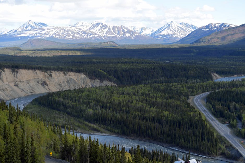
How can a tsunami climb nearly half a mile up the side of a mountain? In August 2023, a colossal landslide in southeast Alaska plunged into a narrow fjord, unleashing a megatsunami that sent a wall of water rocketing 1,580 feet—almost 500 meters—up the steep valley walls. This staggering height, confirmed by satellite imagery and field surveys, places it among the highest tsunami run-ups ever documented. While tsunamis are typically associated with ocean-spanning waves from undersea earthquakes, this inland event was driven by a sudden, massive slope failure. The incident raises urgent scientific questions: Are such extreme events becoming more frequent? And could climate change be tipping the balance in geologically fragile landscapes?
\n\n
What Caused the Alaska Megatsunami?

\n
The event originated in the remote Barry Arm fjord, part of Prince William Sound, where a large section of a mountain slope—estimated at over 200 million cubic feet of rock and ice—collapsed after weeks of unusually warm temperatures and heavy rainfall. This landslide funneled directly into the narrow, U-shaped fjord, displacing an immense volume of water in an instant. The resulting wave surged upward along the confined walls, gaining height through a process known as wave shoaling and topographic amplification. Unlike oceanic tsunamis that lose energy over distance, this localized megatsunami was amplified by the steep, glacially carved terrain. Researchers from the University of Alaska Fairbanks and the U.S. Geological Survey confirmed the 1,580-foot run-up using high-resolution satellite data from Planet Labs and pre- and post-event LiDAR scans. Such heights are rare but not unprecedented—similar events occurred in 1958 at nearby Lituya Bay, where a wave reached 1,720 feet.
\n\n
What Evidence Supports This Extreme Wave Height?

\n
Scientists identified the wave’s peak elevation by analyzing distinct trim lines—visible scars in the vegetation and soil—up to 1,580 feet above sea level. These markers, captured in satellite images from NASA and commercial providers, show where the wave scoured away trees and rock. Seismic data from regional monitoring stations also detected the landslide as a magnitude-3.7 event, with ground motion consistent with a rapid mass movement rather than tectonic activity. Dr. Kristy Tiampo, a geophysicist at the University of Colorado, explained in a ScienceDaily report that the combination of slope steepness, rock volume, and fjord geometry created a ‘perfect storm’ for extreme wave amplification. Historical records show Barry Arm has been under surveillance since 2020, when satellite radar revealed accelerating deformation of the slope—a warning sign of potential collapse. Despite no immediate threat to large populations, the area is frequented by boats and cruise ships, making such events a growing concern for maritime safety.
\n\n
Are Scientists Overstating the Climate Connection?

\n
While many researchers point to climate change as a contributing factor, some geologists urge caution in directly linking individual events to global warming. They argue that landslides in glaciated fjords have occurred for millennia due to natural slope instability, glacial retreat, and seismic activity. Dr. Marten Geertsema of the British Columbia Ministry of Forests noted that while warming temperatures can accelerate permafrost thaw and reduce slope cohesion, the mechanics of such collapses are complex and site-specific. Not every deglaciating fjord produces megatsunamis, and historical records remain sparse. Additionally, the 1958 Lituya Bay event occurred before the current era of rapid climate change, suggesting that extreme waves can arise without anthropogenic influence. Still, a growing body of research, including a 2021 study in Nature Communications, indicates that the frequency of large slope failures in formerly glaciated regions is increasing in step with rising temperatures—particularly in Alaska, the Canadian Rockies, and the Himalayas.
\n\n
What Are the Real-World Implications of Such Events?

\n
The Barry Arm event, while remote, underscores the growing risk of secondary geohazards in a warming world. With glaciers retreating at unprecedented rates—Alaska’s ice fields have lost over 75 gigatons of ice annually since the 1990s—previously supported slopes are becoming unstable. In 2022, a landslide-induced wave in the Taan Fiord reached over 300 feet, damaging boat infrastructure. The 1,580-foot run-up in Barry Arm didn’t generate a distant tsunami, but had it occurred during peak tourist season, a passing vessel could have been obliterated. Authorities now use InSAR (interferometric synthetic aperture radar) to monitor at-risk slopes, but coverage is limited. Indigenous communities, scientists, and maritime operators are calling for expanded early warning systems. The U.S. National Tsunami Hazard Mitigation Program is evaluating whether to include landslide-driven waves in coastal alerts, especially in fjord-rich regions like Alaska and Southeast Asia.
\n\n
What This Means For You
\n
While megatsunamis in remote fjords don’t pose a direct threat to most people, they are a visible signal of how climate change can amplify geologic risks in unexpected ways. Infrastructure planning, tourism safety, and hazard monitoring must adapt to these emerging threats. For those living near mountainous coastlines or planning expeditions to glacial regions, understanding local geohazards is now as important as checking weather forecasts. The science is clear: as glaciers shrink, the ground above becomes less stable, and the potential for sudden, catastrophic events grows.
\n
Could more of these extreme landslides be on the horizon as global temperatures rise? And how can scientists better predict which slopes are most likely to fail? With limited monitoring and vast, inaccessible terrain, forecasting the next megatsunami remains one of the toughest challenges in modern geoscience.
Source: Theconversation