- El Niño has surged beyond predictions, revealing new data on its unprecedented strength.
- The 2023 El Niño event has become one of the most powerful on record, rivaling extreme episodes of 1997-1998 and 2015-2016.
- Sea surface temperatures in the Niño 3.4 region have remained above 1.5°C above average for five consecutive months.
- Subsurface heat content has surged to levels not seen since record-keeping began in the 1970s.
- El Niño is evolving faster and more fiercely than climate models predicted, pushing the boundaries of what scientists once considered possible.
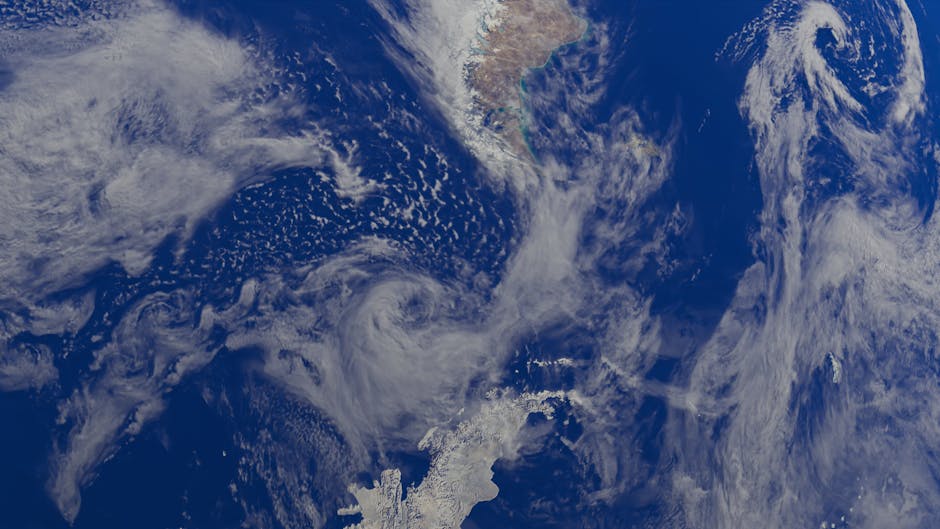
Off the coast of northern Peru, fishing boats sit idle in the harbor of Paita, their nets dry, their crews restless. The normally cool, nutrient-rich waters that sustain anchovies and feed millions of seabirds have turned warm and glassy, shimmering under a relentless sun. Farther west, in the central Pacific, satellites detect vast stretches of ocean glowing red with heat anomalies—swathes of water two to four degrees Celsius above average, stretching across millions of square kilometers. Weather stations in Indonesia report near-total suppression of rainfall, while floods submerge towns in Argentina. This is not a future projection. This is El Niño in real time—evolving faster and more fiercely than climate models predicted, pushing the boundaries of what scientists once considered possible.
El Niño Reaches Unprecedented Strength

The 2023 El Niño event has escalated into one of the most powerful on record, rivaling the extreme episodes of 1997–1998 and 2015–2016. According to data from NOAA’s Climate Prediction Center, sea surface temperatures in the Niño 3.4 region—the key monitoring zone in the central Pacific—have remained above 1.5°C above average for five consecutive months, meeting the official threshold for a strong event. But recent satellite observations and deep-ocean sensors reveal a more alarming picture: subsurface heat content has surged to levels not seen since record-keeping began in the 1970s. Atmospheric feedbacks, including the weakening of trade winds and the eastward shift of tropical convection, are now self-reinforcing the warming pattern. The World Meteorological Organization has issued a global alert, warning of heightened risks of droughts, wildfires, and extreme rainfall in the coming months. Climate models, even those incorporating anthropogenic warming, did not anticipate such rapid intensification.
The History Behind the Heat

El Niño, part of the broader El Niño–Southern Oscillation (ENSO) cycle, is a natural climate phenomenon driven by shifts in ocean-atmosphere dynamics across the equatorial Pacific. In a typical cycle, weakened trade winds allow warm surface waters to migrate eastward from the western Pacific, disrupting upwelling and altering global weather patterns. Historical records, including coral isotope data and ship logs, suggest El Niño events have occurred for centuries, but their frequency and intensity appear to be changing. Research published in Nature Climate Change indicates that since the late 20th century, the proportion of extreme El Niño events has doubled, a trend closely correlated with rising global temperatures. While El Niño itself is not caused by climate change, warmer baseline ocean conditions provide more fuel for these events, making them more likely to reach catastrophic levels. The 2023 episode is unfolding against a backdrop of record global ocean heat content, with 2023 already confirmed as the warmest year on record.
The Scientists Steering the Forecast

At the International Research Institute for Climate and Society at Columbia University, climate scientist Dr. Michelle L’Heureux has spent two decades decoding ENSO signals. Her team, along with counterparts at Australia’s Bureau of Meteorology and Japan’s Meteorological Agency, has been working around the clock to refine predictions. “We’re seeing behavior that our models weren’t trained on,” she said in a recent briefing. “It’s like driving a car with a GPS that’s never encountered a storm of this magnitude.” Her sentiment is echoed by Dr. Wenju Cai of CSIRO, who has led studies on climate change’s impact on El Niño. These researchers are not only updating models in real time but also grappling with how to communicate escalating risks without triggering alarmism. Their work is increasingly shaped by urgency—not just scientific curiosity—as governments and humanitarian agencies demand actionable forecasts for food security, water management, and disaster preparedness.
Global Consequences of a Supercharged El Niño

The ripple effects of the 2023 El Niño are already being felt. In Southeast Asia and Australia, suppressed rainfall has heightened wildfire risks and strained hydropower capacity. Southern Africa faces a second consecutive year of drought, threatening maize harvests and exacerbating food insecurity for millions. In the Americas, the southern United States is bracing for an active hurricane season, while South American nations along the Pacific coast confront deadly floods and landslides. The United Nations Office for the Coordination of Humanitarian Affairs has activated early-response funding in 12 countries. Agricultural economists warn of price spikes for commodities like coffee, sugar, and rice. Meanwhile, marine ecosystems are under severe stress: coral bleaching events have been reported in the Galápagos and French Polynesia, and fishery collapses could have long-term economic consequences for coastal communities.
The Bigger Picture
What makes the 2023 El Niño especially concerning is not just its intensity but what it reveals about the Earth’s climate system under stress. As greenhouse gas concentrations continue to rise, natural variability is no longer operating within historical bounds. Events once considered rare are becoming more frequent, more extreme, and harder to predict. This shift challenges the foundational assumptions of climate modeling and infrastructure planning. It also underscores a sobering truth: even if global emissions were halted today, the ocean’s thermal inertia would continue to drive extreme events for decades. The current El Niño is not an outlier—it may be the new normal.
Looking ahead, scientists expect the El Niño to peak between December 2023 and February 2024 before gradually declining. But its aftermath could include a rapid transition to La Niña conditions in late 2024, potentially triggering another wave of climate disruptions. The key challenge now is improving adaptive capacity—through better early warning systems, resilient agriculture, and international cooperation. As the planet’s climate gears spin into uncharted territory, the ability to anticipate and respond will define not just seasonal forecasts, but the stability of societies worldwide.
Source: Gizmodo